
 Global Change
Key points
- The growth rate of greenhouse gas concentrations was higher than ever before in 2024.
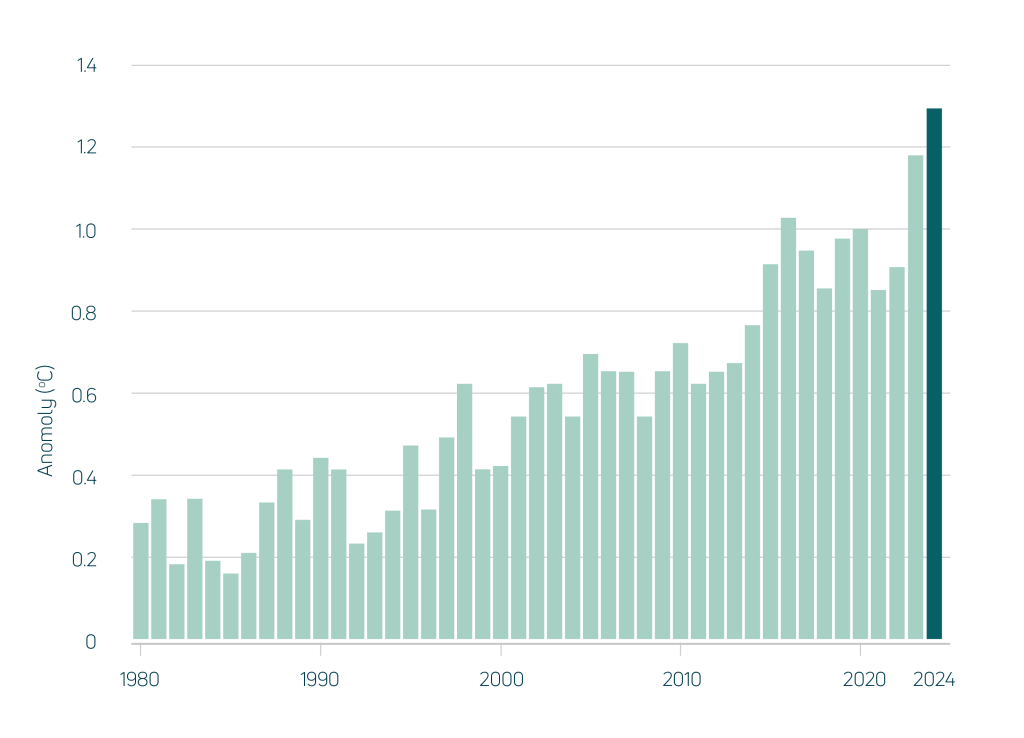
- Globally the year was once again the hottest year on record and sea ice remained low.
Atmospheric CO₂ concentration increased by 3.5 ppm, the fastest increase ever measured. Concentrations rose 38% faster than the previous year and 60% faster than the average 2000–2023 growth rate. The high increase was due to a continued increase in fossil fuel emissions and wildfire activity associated with El Niño conditions. The average CO₂ concentration reached 425 ppm, a 34% increase from 1960.
Global average air temperature was the highest on record by a considerable margin. It was 0.11 °C higher than the previous year, 1.29 °C above the 20th-century average and 1.6 °C above the pre-industrial average. The last ten years (2014–2024) all rank as the ten warmest on record.
The maximum ozone hole extent was 14% smaller than the previous year. It was 10% smaller than the 2000–2023 average and 25% smaller than the maximum extent observed in 2000. The ozone hole has not shrunk over the last two decades but may have stabilised.
Sea ice extent was 0.5% less than the previous year in the Arctic and 5.3% more around Antarctica. Ice extent on both hemispheres combined was 2.3% more than the previous year but still the second-lowest since the start of records in 1978 and 7% lower than the 2000–2023 average.
Where does this data come from?
Measures of the condition of natural resources and ecosystems were derived from several spatial data sources.
Weather data was derived by combining station satellite and weather forecast model data.
Data on land cover, inundation, fire, soil condition and vegetation leaf area were derived by automated interpretation of satellite imagery. Biodiversity analysis was based on the DCCEEW SPRAT database and Threatened Species Index (TSX), providing measures of change in the relative abundance of Australia’s threatened and near-threatened species at national and regional levels.
The other indicators were estimated by combining the weather and satellite data in ANU’s environmental data assimilation system, OzWALD.
For further details on data and methods or to download the data, read more.